Andes Shifting
In the sequence of 7 of 10 scenarios, the S America roll comes after:
- the tipping of the Indo-Australian Plate (which occurred in the latter half of 2010 when Pakistan lost 10 feet of
elevation near the Indus River valley),
- the sinking of the plate tongue holding Indonesia (which started December 23, 2010 and is still ongoing, not yet
completed),
- the folding of the Philippine and Mariana plates (which recently started).
But as the Zetas say, the trend is evident before the big event, and the big event does not occur all at once, but is paced.
Thus, it is hard to say when a scenario starts, exactly. Certainly, the sinking of Indonesia and the folding of the plates has not
completed, but the S American roll is trying to start. As evidence, the obvious mountain building and crumbling along the
Andes. Note these four incidents, all occurring during the past week or so, are all in the Andes.

- Bogotá Risk Area
February 24, 2011
http://www.elheraldo.hn/Ediciones/2011/02/25/Noticias/Copeco-visita-zona-de-riesgo-en-Bogota
- The works of mitigation made on that mountain of more than two thousand meters above the sea level. Due to
cracks in the mountain, have gone 110 hectares, with nearly four thousand homes. La Estancia was declared
in 2000 as a high risk area. in the last five years the disappearance of 15 the 28 neighborhoods that were on
the slopes.
-
- Ecuador: 8 of 31 Houses at Risk Fell to the Estuary Salado
February 23, 2011
http://www.eluniverso.com/2011/02/23/1/1445/8-31-casas-riesgo-cayeron-estero-salado.html
- In five minutes, and all the houses had collapsed.
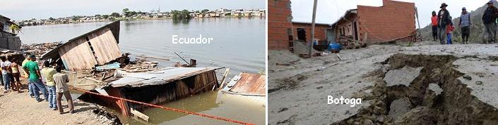
- Bolivia: About 250 Families Lost 100 Homes in Kupini II
February 27, 2011
http://www.laprensa.com.bo/noticias/27-2-2011/noticias/27-02-2011_12208.php
- The mayor of La Paz, Luis Revilla, impacted by the magnitude of the event, told La Prensa that when making
an early morning inspection yesterday, found 40 homes affected by ground movement, but in the afternoon
and reached about 100 homes.
A massive crack opened in Peru, showing shifting ground so common in mountain building regions.
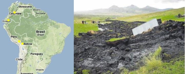
- Incredible: The Earth Opens and Lets Large Crack in Puno
February 25, 2011
http://www.peru.com/noticias/portada20110225/141018/
- The people of Chucuito, in Puno , expressed his surprise at the appearance of a huge crack of 100 meters wide
and three miles long. Even the Geophysical Institute of Peru in the area denied that there has been an
earthquake. The Civil Defense Institute of Puno said that geologists have come instead to investigate the
phenomenon.
Per the Zetas, the S American roll cannot be expected to just be one big event, but they declined to give a time frame.
ZetaTalk Prediction 2/26/2011: The S American roll will not take place in an instant, from start to end, as is obvious
from the preliminary movement already taking place. The region of the N Andes fault line is suffering mountain
building. The Caribbean Plate off coast from Colombia recorded sinking in 2010, and Panama is flooding due to
preliminary sinking, even having to close its locks at one point for the first time in its 125 year history due,
supposedly, to rain. Where this will proceed in steps and stages, one should not assume a leisurely pace! Trauma
from magnitude 8 and 9 quakes along the Andes will still strick suddenly, and the crumbling of Central America will
likewise be traumatic and strike suddenly for a given location. When two mountain ranges moves closer together, for
those in the valley this cannot be anything other than a horrific trauma. Likewise with sinking, which for those
islands due to lose hundreds of feet in elevation, can place the inhabitants in boats, if they are lucky, with little
warning.
Caribbean Tilt
China has begun exploring alternatives to the Panama Canal, as to drag cargo by boat around the tip of S America is tedious.
- China in talks over rail rival to Panama Canal
February 14, 2011
http://edition.cnn.com/2011/BUSINESS/02/13/china.panama.ft/index.html?hpt=T2
- China is in talks to build an alternative to the Panama Canal that would link Colombia's Atlantic and Pacific
coasts by rail -- a move that Bogotá also hopes will spur Washington to push for Congressional approval of a
US-Colombia free-trade pact. Colombia has long dreamt of building an alternative to the Panama Canal.
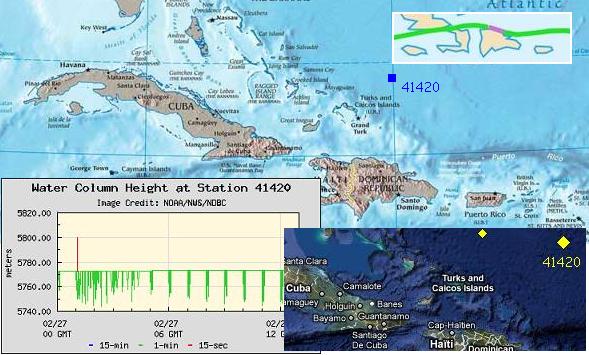
While Panama sinks, the upper part of the Caribbean Plate is loosening. Buoy 41420, just above the Bahama Escarpment,
went into event mode for days. The plates involves in the S America roll have begun to move!
NYC Exploding Manholes
The N American continent is likewise showing the stress of the tug to the west, the diagonal pull which puts the N American
continent into a bow. Quake swarms and sinkholes are nothing new, but 65 exploding manholes in New York City is an eye
catcher!

- Harsh Winter Triggers New York City Manhole Explosions
February 4, 2011
http://www.reuters.com/article/2011/02/04/us-weather-manholes-idUSTRE71374I20110204
- Record snowfall is turning the city's mean streets even meaner, with 65 manholes exploding or catching fire
since New Years. So what's going on? In a word: winter. Consolidated Edison, which supplies power to the
five boroughs of New York City and Westchester, pointed to a mix of salt, spread on the roads during storms,
and melting snow or ice as the culprit. When salty water contacts a corroded cable or underground utility box,
fire or explosion can result.
Is this related to the bow pressure the N American continent is enduring? Yes indeed, per the Zetas, and also related to those
high rises with their footings bedded on rock!
ZetaTalk Explanation 2/19/2011: Despite protestations that this is all caused by lots of melting snow and the need to
salt the roads heavily, 65 exploding manholes is hardly the result expected. Electrical outages would be expected, if
anything at all. Were these electrical systems installed by dumbies? The equipment is not on the floor! The
establishment must say something to avoid addressing the Earth changes, and it is always considered safe to blame
the weather. New York City has been built on rock, the high rise buildings footed on rock, but this does not mean
that methane gas has not accumulated between the layers beneath these footings. In fact, it is the footings
themselves that are part of the problem. During a violent wobble, sinkholes and crevasses appear in stretch zones
because the ground is pulling in first one, then another, direction. This drops soft soil down any vent that has been
established by this action, and thus the sinkhole. In like manner, these vents can allow gas to rise. Stick a rod into
the ground and move it back and forth, and what do you get? Soil or rock on either side will be pushed away from
the rod, thus forming a vent for gasses to rise.
Indonesia Rain Blame Game
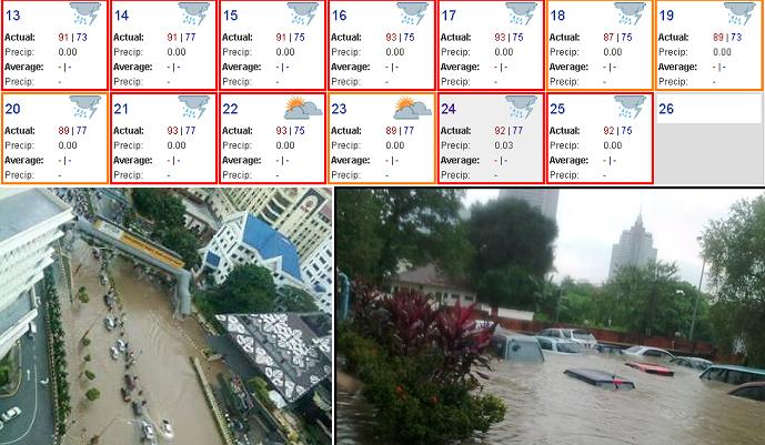
During the sinking of Indonesia, it seems that every article must mention rain as the cause of flooding, as the de rigor excuse.
A bit of checking has shown how far off these excuses are. For instance, the flooding in Kuala Lumpur on the Malay
peninsula, announced on February 25, 2011, show no measurable precipitation on February 25, 2011 and only .03 inch
during the entire week prior! Hardly the "heavy rains" noted in the news article.
- Malaysia: Flash floods hit Kuala Lumpur
February 25, 2011
http://muslimeen-united.blogspot.com/2011/02/kuala-lumpur-dilanda-banjir-kilat.html
- Heavy rains in the capital this afternoon caused some major roads flooded due to overflowing water from
several rivers such as Sungai Gombak and Sungai Bonus. Following the flash floods as high as about 0.7
meters, a lot of light vehicles were trapped in several major roads in the capital.
Many articles are beginning to omit the de rigor claim that flooding is caused by rains. For instance on the island of Sumatra
near Jambi, where the article states that the flooding is from the sea. Here, there actually was an inch of rain on February
18-19, 2011 totaling .86 inch, but the rain claim was not made.
- Almost week Mendahara Kelurahan Ilir Awash Sea Water Place
February 24, 2011
http://www.mediaindonesia.com/read/2011/02/02/205648/126/101/
- Mendahara Kelurahan Ilir, East Tanjung Jabung, Jambi, ocean tides inundated for several days. The flooding
that occurred nearly a week flooded the homes of a village with a height of nearly one meter. In the past, one
year at a time. It was not as severe as it is today. Currently flooding is more frequent and increasingly
high-alone.
And elsewhere on the island of Sumatra, near Banda Aceh, the press reporting that there was no evidence that the sudden
flash flood came from rain.
- Indonesia: Sudden flooding in Jantho
February 24, 2011
http://www.waspada.co.id/index.php?
- BANDA ACEH - Village Well, Jantho City hit by flash floods. Currently, the water entering the township
population has reached a height of one meter. Residents do not know the water comes, because there was no
rain, suddenly the water was as high as one meter.
Oops, but just three days later on February 27, 2011 the press stands corrected, now mentioning the "rainy season" for
Aceh, though for this location on the February 27 and the week prior, only .16 inch of precipitation occurred. The press is
struggling to blame the flooding on rain, saying "Though rainfall in Aceh Jaya since the last two days is still within
normal limits. You could say this flood due to heavy rainfall in upstream."
- Floods Soak the Seven Villages in Aceh
Feb 27, 2011
http://berita.liputan6.com/daerah/201102/322045/Banjir_Rendam_Tujuh_Desa_di_Aceh
- Adult knee-deep floods also soak schools, rice fields, and existing state roads. Residents worry the water levels
continue to grow. Almost every rainy season, flooding is always coming. During the year 2010 alone, floods
have six times the soak region.
-
- Surround Floods Again West Aceh-Aceh Jaya
February 27, 2011
http://www.hinamagazine.com/index.php/2011/02/27/banjir-kepung-lagi-aceh-barat-aceh-jaya/
- Several large rivers in West Aceh and Aceh Jaya overflowed again led to some areas in two districts
neighboring again surrounded the floods. In West Aceh district, as many as 4200 people from 18 villages in the
subdistrict of East Woyla, some Kaway XVI, and the District Meureubo since Saturday afternoon cooped up
yesterday reported a flood. The accident was due to overflowing of the two major rivers in the region, namely
Krueng Woyla and Meuereubo. Though rainfall in Aceh Jaya since the last two days is still within normal
limits. You could say this flood due to heavy rainfall in upstream.
Then Makassar in the Indonesian islands east of Borneo, where sinking has been reported before, and now, horrors, it has
flooded their stadium! Here they actually had rain for two days in a row, for a total of almost 3", but per the article even the
local meteorologist considered this was not enough to cause this flooding!
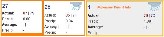
- Stadium Area Flood Mattoanging Makassar
March 1, 2011
http://makassar.tribunnews.com/2011/03/01/kawasan-stadion-mattoanging-makassar-banjir
- Stadium Mattoanging Andi Mattalatta Makassar was also not spared from the flood. The area around the
stadium is the pride of citizens of South Sulawesi floods to the knee man, woman. The road was closed by the
residents for road users is not trapped flood. The reason is many road users that the vehicle broke down due to
exposure to water. Climatology Meteorology and Geophysics Agency (BMKG) Region IV Makassar inform,
the rain that occurred on Tuesday (3/01/2011) today still in the medium category. However Makassar already
flooded everywhere.
And for the first time, in the press, the word "sinking" is used to describe what is occurring to an island at Singapore - "the
island was sinking".
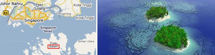
- Leading Indonesian island of Threatened Drowning
February 28, 2011
http://www.republika.co.id/berita/breaking-news/nasional/11/02/28/166553
- Stone Island Chain, which is the leading island Republic of Indonesia and located in the administrative area of
Batam in Riau Islands Province, nearly drowned. The island was only there at low tide. While the tide, the
island was sinking. The island is one of the three outer islands bordering the waters of Singapore. It was only
three to five kilometers from Singapore.
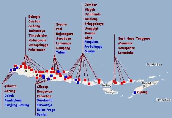
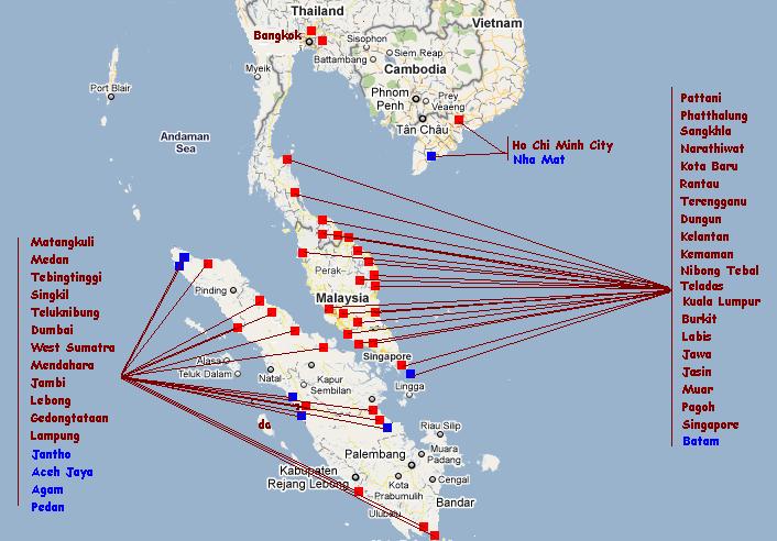
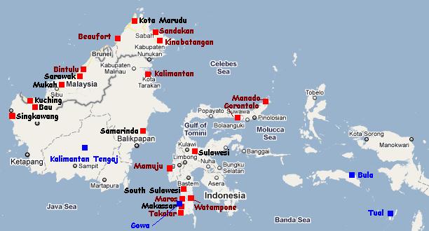
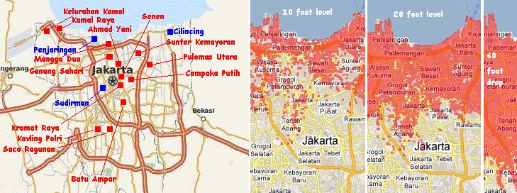
As of March 3, 2011 the sinking status for those lands on the plate tongue holding Indonesia is marked in red and blue, with
blue being those areas experiencing sinking during the past week, as reflected in these news articles.
You received this Newsletter because you subscribed to the ZetaTalk Newsletter service. If undesired, you can quickly Unsubscribe.
|