| |
![]()
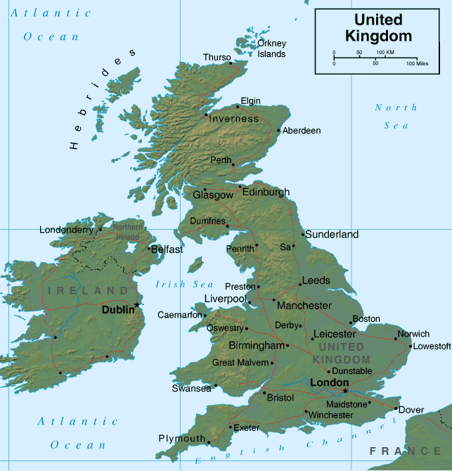
 England
England has traditionally fared well during pole shifts, due to its underlying rock structures. Stonehenge attests to this, sustaining a few sharp jolts but avoiding extended jiggling that is often more destructive of heavy structures. However, the Atlantic is anticipated to widen greatly during the coming pole shift, and this will affect England as well as the islands lying to the west of her. During the week of rotation stoppage, lands bordering the Atlantic, due to the stretch that will occur as the Earth continues to pull East, attempting to continue turning and resisting the stoppage, will drop. In England this will results in a permanent drop of 75 feet. England, however, will not go completely under the waves, but in addition to the stretch, wave action during the shift must be taken into account. At first, during the Earth's rotation stoppage, the waters surrounding England may move north toward the pole. Then, during the shift, the waters will dramatically drop as the Atlantic widens. Here is where the danger lies, as within hours there will be a return of the water, with uncontrolled sloshing and the overall drop in sea level will be apparent! Stay on high ground for at least a day.
ZetaTalk ™
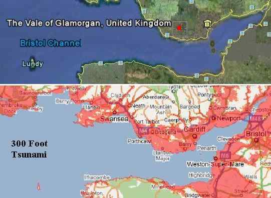
We have stated that England, and the UK in general, can anticipate a permanent drop of 75 feet in elevation due to the pole shift. This combined with the 675 foot drop in elevation due to sea level rise within 2 years after the shift puts any land under 750 feet in today's elevation under water. The islands of the UK are not large, so our advice to seek high ground, at least 100 miles from a coastline and 200 feet above sea level, must be altered for the UK. Seek the high mountains! Given the few miles that must be traveled, during the last weeks you should be camped on high ground. Prorate the height of the tidal waves. If 500-600 feet at the coast, and 200 feet 100 miles inland, then what would 50 miles inland present? We have advised for those that would be affected by the European tsunami prior to the pole shift, where our estimate was 200-300 feet in height, that you should assume half the precaution for the pole shift tidal waves. This same advice applies. Water seeks its level, so that during sloshing there will be no coastline in the UK that is not affected.
ZetaTalk ™
On July 25, 2007 the people at Stratford on Avon were given a warning via UFO that their region would be subject to tidal bore up the Severn and Avon rivers during the pole shift. Our statement at the time was that the pole shift tide will bore up and into central England, washing over this portion of the island. In that the European tsunami is anticipated to be half the height of the pole shift tides, and washing through the English Channel at a height of 100 feet or more, what can be anticipated at this time for the lowlands of England and the eastern coastline along the channel. Rushing water, under force and moving rapidly, not only floods, it bites. Where the European tsunami might not rush all the way into the lowlands in England's interior it will certainly rush into any lowlands along the eastern seaboard and force up the Thames River to roil London's docks. This will not be a flood, but a scourge, tearing away buildings and docks and all unfortunate to be in its way at the time.
ZetaTalk ™
The Bristol Channel will experience tidal bore during the European tsunami. This fact is the reason our estimate for the water height to strike the UK coast was from 200-300 feet. Why this variance, unless there were factors that would affect the water height. Tidal bore occurs when the water has an increasingly more narrow path before it, and thus must rise to accommodate the press of water coming behind it. A bore does not stop until the height of the water pushes back onto the oncoming water with an equal force. Momentum of the oncoming water also is a factor. The European tsunami will be a lot of water, coming at great force and speed. For those who want specifics on just which river bottom or ravine will experience a bore, we suggest seeking the advice of a hydrologist. Models of the terrain can be built, and subjected to water force in a lab pool, for instance. Nancy and ourselves will not have time to address every nitch in the UK. For those who cannot arrange for this analysis, assume the worst case situation, 300 feet in height, and utilize the free Google Maps facility to determine if you are in the red or in the clear.
ZetaTalk ™
Note European Tsunami
commentary.
Note European Migratrion
commentary.
Note European Tsunami Source
commentary.
Note European Population
commentary.
Note 7 of 10 Pace Slowed commentary.
