The 7 of 10 plate movements could be seen during September,
2013. The current plate movements and their historical
precedence were apparent in the St. Lawrence Seaway spread, the
S America roll, the Caribbean tilt crumbling Trinidad, the
African roll and its clear history in the Mediterranean and Afar
Triangle, the history of Atlantis, and the sinking India plate
creating mud islands along the plate border off coast from
Pakistan.
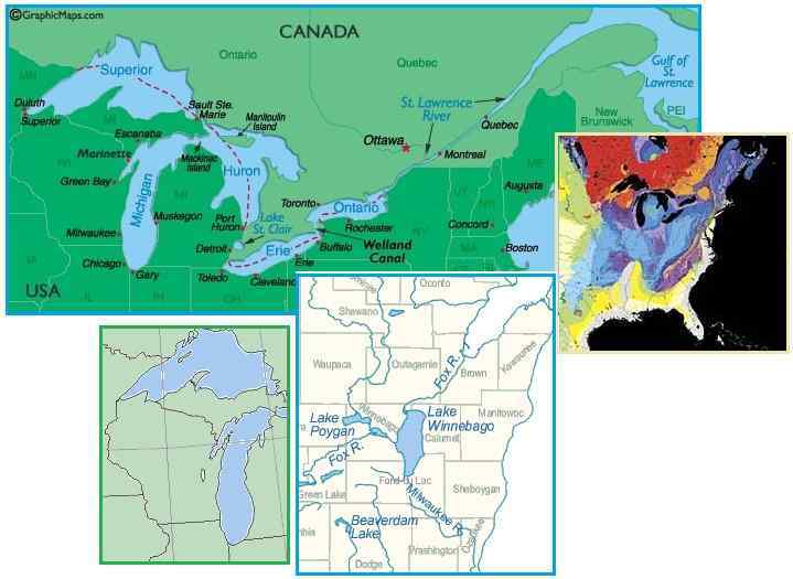
Green Bay Split
The Zetas explained early in the ZetaTalk saga that Wisconsin
would participate in the tearing of the St. Lawrence Seaway, and
detailed that they would involve the split at Green Bay where a
prior split can be seen along the peninsula. Green Bay and
Duluth will feel the pain. For Wisconsin, the split will be no
small thing, potentially ripping Wisconsin into two parts with
Lake Michigan reaching the Mississippi.

ZetaTalk Prediction
2001: The
Seaway split has chosen to run through Duluth, MN and on west
from there rather than through Wisconsin where the bond
between the various rock stratas is of a stronger nature. The
Seaway can be expected to proceed, thus, beyond Duluth,
creating a crevasse again through upper Minnesota, with
sympathetic rumpling of lands all the way to the Black Hills.
Wisconsin has been splitting along rock strata too, creating
the Green Bay peninsula at the juncture of Green Bay and the
body of Wisconsin, as the peninsula has a different rock type.
This split will continue and widen, creating a bay all the way
to Madison and potentially through to the upper Mississippi.
The tearing of Wisconsin will not wait until the Pole Shift, per
the Zetas, but has already started. Green Bay developed
a hum in 2008, and booms throughout Wisconsin from
Clintonville through Montelo to
Baraboo occurred in 2012. A crevasse
appeared in the Michigan peninsula in 2010, growing to
this day. Now a bridge crossing the Fox River in Green Bay has
slumped, some of the footings sinking suddenly. Green Bay is
ripping apart, and only the start, per the Zetas.
- Sinking Pier Closes Leo Frigo Bridge
Indefinitely
September 25, 2013
http://www.wbay.com/story/23522780/2013/09/25/update-5-leo-frigo-bridge
- The Department of Transportation
says the Leo Frigo Bridge on Interstate 43 is closed
indefinitely after a pier on the east side of the bridge
settled, causing a massive sag.
- Investigation Begins for Leo Frigo
Bridge
September 25, 2013
http://www.nbc26.com/news/local/Investigation-Begins-for-Leo-Frigo-Bridge
- Inspectors say this dip is
something they've never seen before.
ZetaTalk Prediction
9/28/2013: The
tearing of the rock under the I-43 bridge over the Fox River
at Green Bay should not be a surprise, as Wisconsin has
clearly torn in this region in the past. We warned over a
decade ago that Wisconsin would participate in widening of the
Seaway, and the Green Bay hum which appeared in 2008 was a
clear warning that the rock stress had started.
Wisconsin is ripping open along a line that follows the
Peninsula down along the Fox River toward Madison, the pulled
rock evident in the small lakes along that line. The booms
that proceeded from Clintonville to Montelo to Baraboo in 2012
parallel that line. What does this mean for Wisconsin?
At the hour of the Pole Shift
Wisconsin will find Lake Michigan arriving almost to Nancy’s
toes at Baraboo and Madison. The split at Green Bay will rent
apart, traveling along the thin crust that is the Fox River
bed, then splintering in many directions along other thin
crust areas. Prior to the Pole Shift the New Madrid adjustment
will also tear Wisconsin. The New Madrid Fault Line runs past
Chicago and then below the Great Lakes through Ohio. The rock
structures that are holding the Seaway together will be
weakened. Michigan, near Detroit, has a regular hum from
stressed rock. All states and provinces along the Seaway
should expect tearing well before the Pole Shift.
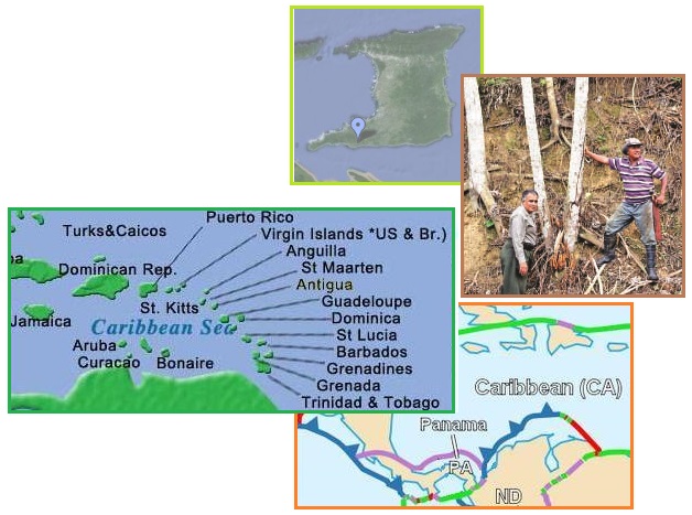
Trinidad Sinking
The Zetas have predicted that Trinidad will be greatly affected
by the S American roll, due in part to the fact that the S
American Plate border cuts right through the island of Trinidad.
But for the most part, as the S American roll progresses,
Trinidad will be pushed down along with the entire southern
portion of the Caribbean Plate, which tilts.
ZetaTalk Prediction
1/15/2011: Islands
just to the north of S America will be affected the most such
that Barbados to Tobago may sink entirely except for the
highest points, losing several hundred feet in elevation, and
Trinidad will be torn apart in addition to sinking as it rides
on the plate border. A plate, being solid rock in layers,
tends to move as one. Thus if the southern part is pushed
down, it will tilt, the northern part lift up.
ZetaTalk Prediction
1/15/2011: Aruba,
Bonaire, and Curacao ride on the hump, and thus will survive.
Islands just to the north of S America will be affected the
most such that Barbados to Tobago may sink entirely except for
the highest points, losing several hundred feet in elevation,
and Trinidad will be torn apart in addition to sinking as it
rides on the plate border.
Though the S American roll has barely started, there has been no
confirmation of sinking or crumbling in Trinidad until this past
month.
- Sinkhole in Carapal
September 26, 2013
http://www.trinidadexpress.com/featured-news/Sinkhole-in-Carapal
- It is a strange occurrence to
Trinbagonians when on waking one morning we find that a
portion of our land has begun to sink. A large area that
was level the day before had sunken significantly. Bois
canot, coconut, mango and other trees still remained
standing—but at a lower level. After some time, the land
dropped still further—by as much as 25 feet in some
places. A clean drop in the earth entailing a block
200 feet long by 25 feet wide, and more in some places.
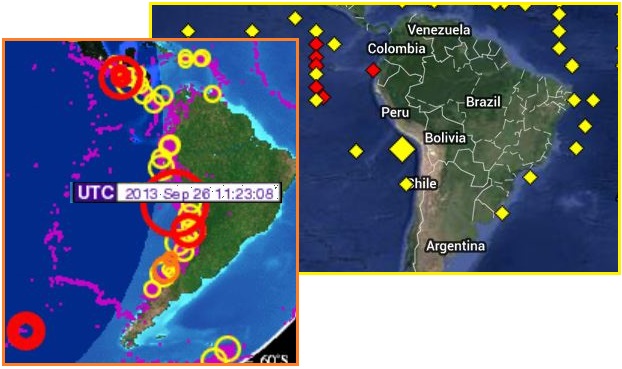
The S American roll has likewise been seen in recent quakes
along the Andes, and by active buoys on the Nazca Plate off the
coast of S America. On September 26 S American rolled a bit, and
on September 26 Trinidad crumbled a bit in synch - the 7 of 10
plate movements predicted by the Zetas, in play.
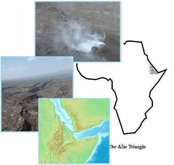
African Roll History
Has Africa rolled in the past? Looking closely at a relief map
of the Afar Triangle, one can see the heel of the Arabian boot
fitting precisely into the dent of the Afar Triangle. Clearly
they were pulled apart in the past. Per the Zetas, this explains
the odd magma pattern under the Afar region, puzzling
scientists. The entire Afar Triangle is a hardened magma scar.
- Ethiopia's Giant Underground Blob of
Magma Puzzles Scientists
September 17, 2013
http://www.nbcnews.com/science/ethiopias-giant-underground-blob-magma
- Models predict that at spreading
ridges, magma should sit just under the rifts, in the
crust. That's what geoscientists see in the oceans, at
places such as the Mid-Atlantic Ridge and the Juan de Fuca
Ridge. But not only is the giant pool at Afar extremely
deep, but it is also mostly below the sleeping Badi
volcano, many miles west of the scene of a 2005 series of
underground magma intrusions.
ZetaTalk Explanation
9/28/2013: One
can see from a relief map of the area that the Afar Triangle
was formed from magma as the Arabian Plate pulled east. The
heel of the boot fits exactly into the space where the Afar
Triangle lies. We have stated that the African Roll has
happened repeatedly during past Pole Shifts, causing the Red
Sea to pull apart and the African Rift Valley to spread. This
process is and has been active in the past, leaving scars in
the form of hardened magma. Unlike the hardened magma along
the Atlantic Rift, which tears dramatically in sudden large
episodes, like during the hour of the Pole Shift, the hardened
magma in the Afar Triangle and the African Rift Valley are
smaller injuries, in numerous short successions. This
ultimately causes more scaring.
The line of lakes along the Israeli/Jordanian border is another
historical indication of the African roll in the past. The
development of over 3,000 sinkholes around
the Dead Sea lately is a sign that the African roll is again in
process, as are the plethora of landslides in the Mediterranean
near the Maltese Islands, as noted on this Pole
Shift ning blog. The African roll leaves its mark through
the Mediterranean Sea and down through the Red Sea and on to the
Rift Valley in eastern Africa.
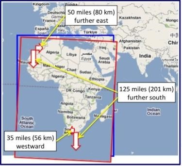
How would Atlantis, rumored to be west of Gibraltar, have fared
during prior African rolls? It would have been in danger of
being crumbled or, more likely, sunk as Africa dropped southward
during its roll. Is there any evidence that the Annunaki, the
residents of Atlantis, were concerned about their city’s future?
Per the Zetas, clear geo terraforming evidence off the coast of
southern Spain shows just such an attempt to delay or prevent
the African roll. This image, taken in 2004 by the US Air Force,
shows an artificial triangular footprint in the rock under the
waves. Compare the location to that of a recently discovered
underwater triangle near the Azores.
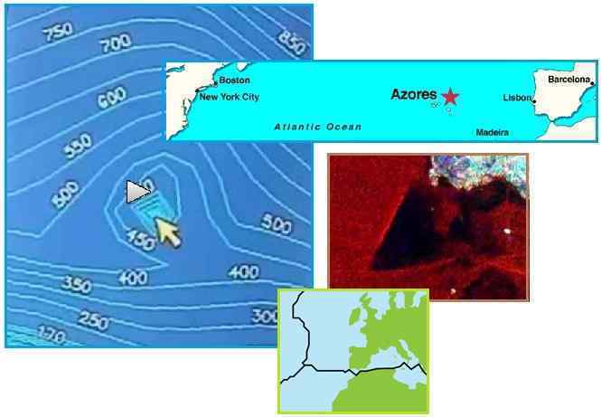
- Sixty Meter Tall Pyramid Found Off
Coast of Azores Island
September 21, 2013
http://www.liveleak.com/view?i=c16_1380022655
- From as far back as Plato it was
suggested the original builders of the pyramids lived west
of Gibraltar. The newly discovered Pyramid is sixty meters
tall with a base of approximately 8,000 square meters. It
is around forty meters below water and aligned with the
four cardinal compass directions, similar to the Great
Pyramid of Giza. The Azores are a chain of nine volcanic
islands in three main groups that are 930 miles west of
Lisbon. They are above what is known as a geological
triple junction where the North American, Eurasian, and
African tectonic plates meet. The location of the pyramid
has been below water for 20,000 years since the last ice
age.
- Image of the Portuguese Coast
August 31, 2004
http://ovni.do.sapo.pt/principal/clasport/OeirasOceano/OeirasOceano.htm
- Their formation can not be
attributed to a building made by humans, since the end of
the last glaciation, which made rising sea levels, has
been for thousands of years. This "shaping" is not more
than a "trough" perfectly symmetrical made ??by
"artificial subject" and large weighing thousands of tons.
Here's one of the images taken by a satellite of U.S. Air
Force, equipped with radar and infra-red equipment.
ZetaTalk Explanation
9/28/2013: We
stated early in the ZetaTalk saga that Atlantis was located
off the coast
of Europe, which is land
that is regularly pulled down under the waves
as the Atlantic is pulled apart during Pole Shifts. There have
been a couple notable satellite discoveries during this past
decade that suggest that the site of Atlantis may have been
discovered. In 2004 a compressed triangle in the rock was
found just off the coast of Spain and west of Gibraltar,
clearly not a natural formation. This huge formation was
touching the plate border there between the African Plate and
the Eurasian Plate. The purpose? To slow the African
roll. What of the pyramid shape found near the Azores? The
Atlantic is a broad ocean, where a landing rocket might be
confused as to which direction to turn the gliding rocket.
Atlantis was the target landing strip!
Pakistan Mud Islands
Several mud islands have popped up off the coast of Pakistan,
in synch with a major earthquake in Pakistan. Where this has
happened in the past, for Pakistan, it begs the question – why
should an inland quake cause the sea floor mud to rise? Per the
Zetas, an analysis of the plate movement dynamics explains it
all.
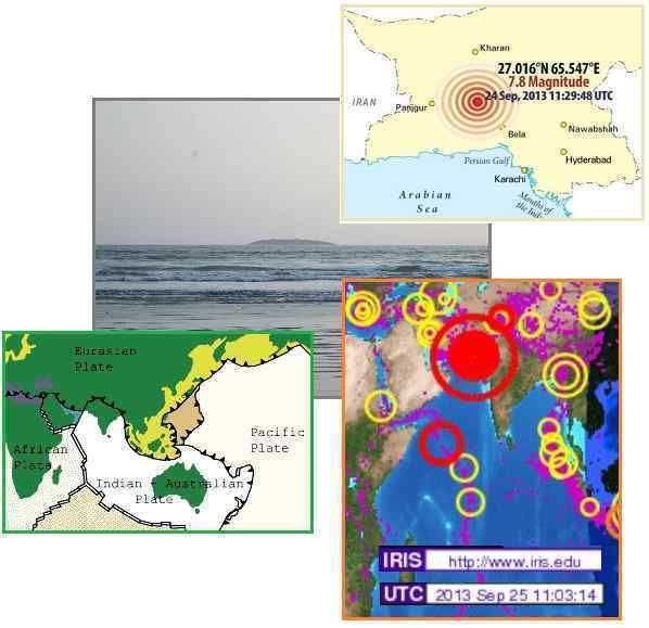
- Pakistan Earthquake Creates New
Island, 'Mud Volcano' to Blame
September 24, 2013
http://www.nbcnews.com/science/pakistan-earthquake-creates-new-island-mud
- On the coast, residents of Gwadar
saw a solitary island rise from the
sea. Seismologists suspect the island is a temporary
formation resulting from a "mud volcano," a jet of mud,
sand and water that gushed to the surface as the temblor
churned and pressurized that slurry under the ocean floor.
Back in the 1940s, a sizable island rose from the sea in
the area, but it didn't last long.
- Quake kills 45 in Pakistan, Creates
New Island in Sea
September 24, 2013
http://mobile.reuters.com/article/idUSBRE98N0HJ20130924?irpc=932
- Tremors were felt as far away as
the Indian capital of New Delhi, hundreds of miles to the
east, where buildings shook, as well as the sprawling port
city of Karachi in Pakistan. The United States Geological
Survey said the 7.8 magnitude quake struck 145 miles
southeast of Dalbandin in Pakistan's quake-prone province
of Baluchistan, which borders Iran.
- Two More Islands Pop Up off Pasni
Coast
September 26, 2013
http://www.aaj.tv/2013/09/balochistan-two-more-islands-pop-up-off-pasni-coast/
- Local people told media that two
more islands, smaller than the previous one, have surfaced
off the coasts of Mara and Pasni areas near Badok and Bul
villages. A similar mud island appeared off Pakistan after
a 2011 earthquake there. It lasted a month or two and then
washed away.
ZetaTalk Analysis
9/28/2013: Clearly
the land based epicenter of this quake in Pakistan involved
the plate border extending under the sea. The Indo-Australian
Plate moved, pushing down under the Himalayas and shifting
ever so slightly toward the north-east as it is driven under
Tibet. The plate is lifting at New Zealand, and rotating
clockwise as it takes this dive. What does this do for the
plate border running through Pakistan? This border shifts, in
a slip-slide manner, while the India side of the border sinks
a bit. It is this sinking that forces mud up to form new
islands.
If this earthquake happened on September 24, 2013 is it related
to the sudden flooding in a nearby Indian state of Gujarat on
September 25, as noted in this Pole
Shift ning blog? As with the sinking of lands on the Sunda
Plate, the establishment denies plate movements and ascribes all
flooding to rainfall. But in a report from India, Gujarat had
very little rain!
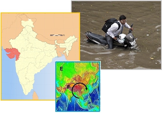
- Indian Floods Force 15,000 to Evacuate
September 25, 2013
http://www.news.com.au/breaking-news/world/indian-floods-force-15000
- Massive flooding has forced 15,000
people to evacuate villages in the west Indian state of
Gujarat. People waded through thigh-deep water on the
streets of the state's main city of Ahmedabad, where
waterlogged cars and buses became stranded.
I am writing from India. On 24th of
September an earthquake of magnitude 7.0 was reported in
Pakistan. This earthquake resulted in an island coming out
of the sea. The scientist say it is a natural phenomenon and
is called the mud volcano. On 25th there was flooding
in Gujarat. This was due to heavy rains. As far as I can
remember, Gujarat had very little rains. Gujarat has a lot
of desert. Can the Zetas care to tell if these two incidents
are related or just coincidence. People here are saying that
the Gods have gone crazy.
Cover-Up Lies
In the dying days of the cover-up over the near presence of
Nibiru, aka Planet X, the desperate cover-up crowd was grasping
at any means to negate the impact of the admission that Nibiru
did indeed exist, and had been in the inner solar system for
years. They knew by the Fall of 2013 that they could not stop
the announcement and all their attempts to assassinate Obama had
failed. Nevertheless, in their desperation to negate the impact
of the announcement on the public, they recently spread lies.
Two of them were obvious lies. One, an Internet rumor that Obama
had lost his mind, i.e. had a breakdown of some sort, and two,
that James McCanney, who had always cloaked Nibiru in the guise
of a comet, thought that Comet ISON was Nibiru. Neither lie was
true, and neither lie moved further than the posture of an
Internet rumor.
- President Obama Reported Sedated
Following Emotional Breakdown
September 21, 2013
http://www.rumormillnews.com/cgi-bin/forum.cgi?read=287692
- Late this afternoon White House
insiders leaked information stating the president has
suffered a mental breakdown and is presently resting and
under a doctors care. This afternoon the National Report
received three calls on our nationwide hot tip line. Two
of the three callers are insiders known to the National
Report to be reliable confidential informants. The
caller unknown to this publication is a low level employee
who could only state that there was some kind of a medical
emergency involving President Obama. The other two callers
known to us are both support personnel within the Obama
administration. Both confirmed this week has been a
political disaster for the president and this has taken a
tremendous toll on him.
ZetaTalk Comment
9/28/2013: This
baseless rumor is being spread for a sinister reason. It is
not so much a spoof as a warning to Obama to cease his
well-laid plans to force the admission that Planet X, aka
Nibiru, is real and in the inner solar system, where it has
been for years. The latest attempt to eliminate Obama was the
Navy Yard shooter. In that the White House is wise to these
types of maneuvers, what next for the frantic cover-up crowd,
which includes politicians such as Dick Cheney and Herbert
Bush and the banking industry? Obama is under a protection,
but few who lean heavily to the Service-to-Self orientation
believe this. They themselves do not receive such protection,
and thus think this a myth. The goal of this rumor is to put
into the public consciousness the possibility that Obama has
gone insane, and thus to package the announcement, when it
eventually occurs, in that light. This ploy, of course, will
not work any more than other ploys, because Russia and China
are participating. Did they likewise lose their sanity?
- Professor James McCanney Reveals NASA
Is Lying About Comet ISON
September 14, 2013
http://beforeitsnews.com/alternative/2013/09/nasa-is-lying-about-comet-ison
- Don’t think NASA would lie?
Think again! This video tells us what we are to expect
regarding Comet ISON in the near future.
- James M. McCanney, M.S. Physics -
Official Home Page
http://www.jmccanneyscience.com/
- September 21, 2013 Is comet ISON a
dud? Comet ISON that NASA has been pumping as the "comet
of the century" is actually at this point a minor
comet. September 20, 2013 This week I discuss the
incredible amount of misinformation emanating from a well
orchestrated disinfo program with NASA and other think
tank and gov alphabet soup agencies. The topics involve
comet ISON. There is a clear and highly orchestrated
mis-use of my name and work on dozens of youtube videos
and web pages and by planted internet nut cases.
ZetaTalk Comment
9/28/2013: Comet
ISON is just another dirty snowball, just another comet, so
why the hype? Comet Elenin was to be used as a distraction for
the Earth changes when the cover-up over the presence of
Nibiru, aka Planet X, was alive and well in 2011. Once again
we have a distraction with Comet ISON, with all manner of
claims about its potential impact on the Earth. ISON is
Nibiru, is the cry. Why, when the admission that Nibiru is
real and in the inner solar system for years is about to
occur, is anyone pushing the ISON disinformation? There are
those who hope the announcement does not occur, so once again
a comet is the excuse. James McCanney has always
espoused comets as the likely persona of Nibiru, or Planet X,
and thus would be the likely spokesperson for ISON, but he is
refusing to cooperate with the cover-up crowd this time.
|