Planet X Photos
The Zetas long ago advised those interesting in capturing the Planet X complex on film use filters that filter for red, light rays
in the red light spectrum. An amateur astronomer from Italy has consistently done that, with spectacular results, recently
posting these on the Pole Shift ning.
I use the thin film that you can cut from an old floppy disk, it seem to be film of cobalt droped iron
oxide. Easy to do, by closing the lens of the camera and good view. But I use also classic Mylar and
orange color.
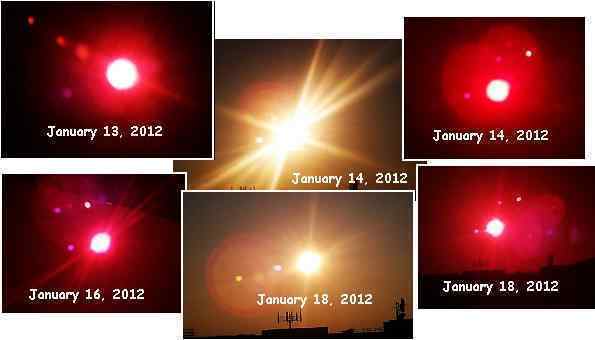
ZetaTalk Comment 1/21/2012: As Alberto's superb photos show, filters repressing the Sun's glare will bring out
different features. Even on the same day, taken we are sure almost in the same hour, the Moon Swirl funneled light
will appear in different places. Why is this? Why would Mylar and a Floopy Disk filter bring forth a different
picture? What comes through the filter is a different color because light rays in this spectrum are allowed to come
through, while others are repressed. Due to the red dust in the tail, a red filter allows more of this color to come
through, and indeed yellow is close in the spectrum to red.
Antarctic Plate Lifting
The Zetas have predicted that during the hour of the pole shift, that portion of the Antarctic Plate bordering the South Atlantic
will rise, thus creating new land between the tip of S America and S Africa.
ZetaTalk Prediction 2/15/1999: The Antarctic plate finds the side abutting the Pacific under pressure, as the plates
due to fold or crumble or subduct in the Pacific begin to do this. This in effect is forcing the Antarctic plate to fold
itself, like a fan, and it resists this pressure to fold. The tendency is rather for the Antarctic Plate to break away from
these bordering plates, so it then becomes free to move. Likewise, along the Atlantic, the spreading plates in the
Atlantic are asking the Antarctic plate to rip apart, which it resists, being a very solid plate. The point that gives, the
weak point, is the border between the Antarctic plate and those in the Atlantic, as these are already weakened
points. Thus, these weak points separate, the Atlantic plates going their way, the Antarctic staying in place.
The Antarctic plate is now free on all sides! The overlapping and compressing plates on the Pacific side represent
pressure and push. The separating and spreading plates on the Atlantic side represent an opening, so the Antarctic
plate moves in that direction. Freed of tight borders, it is free to float or sink in the sea of lava that all plates ride
upon, and as a land plate, being lighter than those that have sunk under the deep seas, it floats - new land! There are
contours on plates, below water, just as there are contours above water. The portion of the Antarctic plate that
emerges above the waves is higher than the rest of the Antarctic plate . Thus, the new land and existing Antarctica
are not joined.
During the steady compression of the Pacific, the Antarctic Plate is pushed down, with the portion bordering the South
Atlantic allowed to push up. We saw quakes all along the Antarctic Plate border last November, 2011 as detailed in Issue
268 of this newsletter. The plate has loosened up and is on the move!
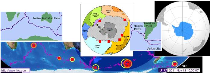
Now a swarm of earthquake on the plate border shared by the Antarctic Plate and both the S American and African plates
recently appeared. This, along with a quake in the center of the South Atlantic, which is spreading apart. Isn't this the process
described by the Zetas? First the plate frees itself from its connections, so it is free to move on the sea of lava. And then it
rises in the Atlantic! It may be on the rise!
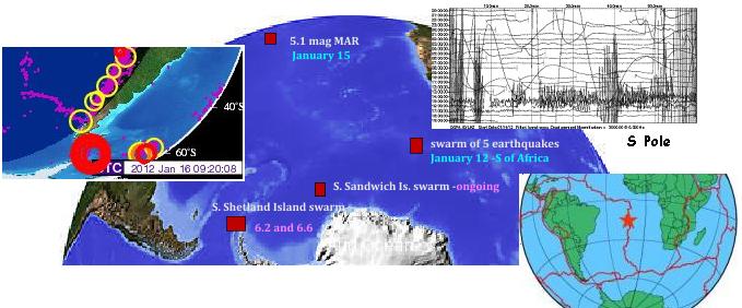
16-Jan-2012 5.1	South Sandwich Islands Region
16-Jan-2012 5.6	South Shetland Islands
15-Jan-2012 5.3	Southern Mid-Atlantic Ridge
15-Jan-2012 5.1 South Shetland Islands
15-Jan-2012 6.2	South Shetland Islands
15-Jan-2012 6.6	South Shetland Islands
15-Jan-2012 4.9	South Sandwich Islands Region
14-Jan-2012 5.0	South Sandwich Islands Region
13-Jan-2012 5.3	South Sandwich Islands Region
13-Jan-2012 5.1	South Sandwich Islands Region
Cartagena Smoking
Folklore reports, and the Zetas confirm, that during the hour of the Pole Shift land overriding a subducting plate can become
so heated from friction that the rock melts.
ZetaTalk Prediction 7/15/1996: Those situated where rapid subduction occurs on areas above sea level may find
themselves on hot earth during the moments following a Pole Shift when the crust stops moving and the plates in
essence slam into each other like a train whose engine suddenly comes to a stop. Here height helps, as the greater
the distance from where friction between the crusts is creating heat, the better. The heat can be great enough to melt
rock, as witnesses who have survived such terrifying sights attest.
This was reported by Velikovsky in his book Worlds in Collision.
The traditions of the Indians (also) retain the memory of this boiling of the water in river and sea. The
tribes of British Columbia tell: "Great clouds appeared .. and such a great heat came, that finally the
water boiled. People jumped into the streams and lakes to cool themselves, and died". On the North
Pacific coast of America the tribes insist that the ocean boiled: "It grew very hot .. many animals
jumped into the water to save themselves, but the water began to boil". The Indians of the Southern
Ute tribe in Colorado record in their legends that the rivers boiled.
During the S American roll, which is picking up the pace, Cartagena reported steaming ground on January 17, 2012. As a
spot on the overriding edge of the hump of the S American Plate, this is certainly where the heat of friction can occur.
VIDEO: http://www.youtube.com/watch?v=SGR-2Kilg70
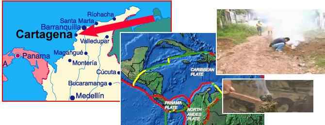
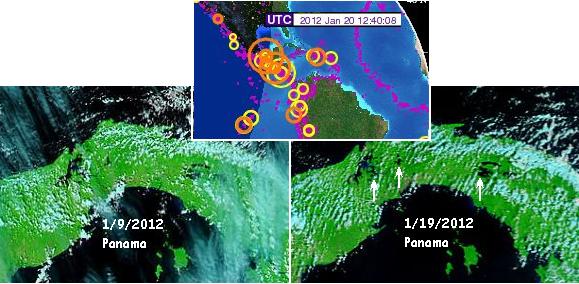
ZetaTalk Explanation 1/21/2012: Cartagena, on the Colombian coastline, is positioned where the S American Plate is
sliding over the Caribbean Plate. As is well known, rapid subduction of one plate under another creates hot ground
on the overriding plate. Might one expect to see the Caribbean Plate sinking a bit thus, on this day? Indeed, MODIS
shows this, a sudden loss of elevation on January 19, 2012. The S American roll is in process, and the pace
accelerating.
If the Caribbean Plate was being pushed down by the roll in this location, does the elevation of Panama, on the western edge
of the Caribbean Plate, reflect this? It certainly seems, by comparing MODIS satellite images, that some loss of elevation has
occurred in Panama.
And mountain building is certainly evident elsewhere along the North Andes fault line. In Ecuador, the land was pulled apart
in two different directions! There was a roar at 4:00 am, and this was the result.
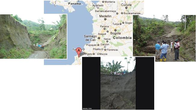
- Land Channel Length 120m and Width 70m Formed in Chura
January 21, 2012
http://www.lahora.com.ec/index.php/noticias/show/1101267306
- The land was divided, with the risk of what might happen a new land slide, so the locals prefer not take place
at the place in front of the fear not to be buried alive.
Mediterranean Stretch
Is the African roll starting to create a stretch zone in the Mediterranean? As the Zetas state, the Africa Roll involves the
continent dropping slightly, creating a larger gap between the continent and Spain, and a larger gap between the continent
and the Sinai Peninsula. Thus, the Mediterranean becomes a stretch zone along the plate border above Africa!
ZetaTalk Prediction 1/1/2011: When the Africa Plate rolls to the east and drops, during the 7 of 10 scenarios, this
will of course affect Egypt and its connection to the Sinai Peninsula. The Straits of Gibraltar will widen by 125 miles,
as Africa drops, and Morocco will move 50 miles further east. Where the Sinai Peninsula is considered part of the
African Plate, the Red Sea is clearly ripping open. Thus both the Red Sea at the Gulf of Suez and the Gulf of Aqaba
tearing up into Jordan will rip open, leaving the Sinai Peninsula positioned like an island with few direct
attachments.
Is there evidence of this lately, along with evidence that the Atlantic is widening, pulling apart, and giving Africa room to
drop? There is indeed! During the same time frame as the quakes along the Antarctic Plate border, the lifting of the Antarctic
Plate into the South Atlantic void, the normally busy Mediterranean was positively asleep! (Note quakes in yellow are more
than two days old.)
13-Jan-2012	3.2 Greece
14-Jan-2012	3.5 Crete, Greece
13-Jan-2012	2.7 Dodecanese Islands, Greece
13-Jan-2012	2.3 Dodecanese Islands, Greece
13-Jan-2012	2.7 Aegean Sea, Greece
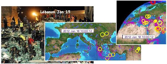
Little bitty quakes in the Mediterranean, but a sudden building collapse in Lebanon in the middle of the night. Typical of
stretch zone accidents.
VIDEO: http://www.youtube.com/watch?v=p3IZaDJ8stA
- Beirut Building Collapse Kills 24, More Missing
January 16, 2012
http://news.yahoo.com/building-collapses-beirut-13-killed-084911253.html
- Thirteen people were killed when a residential building collapsed in Beirut. The five-storey building collapsed
in the Ashrafiyeh district of the Lebanese capital.
Cruise on the Rocks
What caused the Costa Concordia cruise ship to go onto the rocks near the island Giglio? Per the captain, rocks were
suddenly under his ship where he did not expect them.
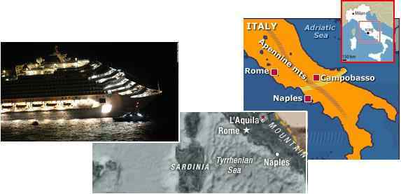
- Captain Arrested, 41 Missing After Italian Cruise Disaster
January 15, 2012
http://nz.news.yahoo.com/a/-/world/12597412/six-dead
- Six people died in the early hours of Saturday after a cruise ship ran aground off the Italian coast in an
accident which forced the coast guard to evacuate over 4,000 people. The Costa Concordia was on a trip
around the Mediterranean when it hit a reef near the Isola del Giglio late Friday. At around 8:00 pm (1900
GMT) the 290-metre-long Costa Concordia cruise shipbegan taking on water and tilting over by around 20
degrees. Passengers heard a large bang and were initially told the ship had shuddered to a halt for electrical
reasons, before being told to put on their life-jackets.
Everyone is blaming the captain, but per the Zetas this is hardly his fault. The Earth wobble sent the globe suddenly south at
that spot, and floating on the water as the Costa Concordia was doing, it found the land moving under it, complete with
rocks. The Costa Concordia was in the bay to the south of the rock, when the rock suddenly moved under it.
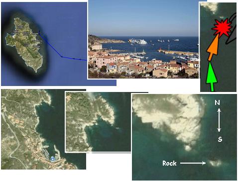
ZetaTalk Explanation 1/21/2012: Europe also participates when the most violent push of the wobble occurs, when the
Sun is high over the Pacific and Europe is in the dead of night. The globe is pushed violently north as the magnetic N
Pole of Earth comes up over the horizon and is pushed away by Planet X. When this happens the globe is pushed
southward on the opposite side of the globe, as the globe rolls as one. What does this do to the rocky shores of Italy
and any hapless ships moored or traveling just off the coast? The land is pushed under the water, and the ship
suddenly finds itself on rocks it though safely at a distance.
And coincidentally, on the same day- January 15, 2012 - three more ships in the region suddenly encountered disaster. One
on the shores of Ireland, one in Albania, and another offshore from the UAE. They snapped their anchors or were thrust on
the rocks. All four incidents on the same day.
- Tanker Sinks near Sharjah Port due to Strong Winds
January 16, 2012
http://gulfnews.com/news/gulf/uae/emergencies/tanker-sinks
- A coast guard official said an oil tanker owned by a UAE-based diesel firm sank about 500 meters from the Al
Hamriya Port, northwest of Sharjah city. The official said strong winds caused the tragedy. The tanker, Lady
Moon, sank at about 6:15 am on Sunday [Jan 15]. The anchor got cut due to the impact of the strong winds.
-
- One Dead as Tanker Sinks in Albania
January 16, 2012
http://www.skynews.com.au/world/article.aspx?id=707811&vId=
- It wasn't immediately clear what caused the Sierra Leone-flagged Edirne to sink on Sunday [Jan 15] about
five kilometres from a harbour in Durres, a day after unloading more than 3000 tonnes of fuel there.
-
- Survivor: 'Rest of the Crew Still Down There'
January 17, 2012
http://www.irishexaminer.com/ireland/survivor-rest-of-the-crew
- The trawler Tit Bonhomme which sank after hitting rocks in Glandore Bay around 6am last Sunday [Jan 15].
The weather was very bad, there were rough seas and then they hit rocks.
Borneo Rumble
Increasingly, the occasional hum beneath our feet has become trumpets, horns, drums, and a veritable roar from the tortured
Earth. That this is due to rock stress, vibrating as it is pushed or pulled apart, is abundantly clear from a report from Borneo.
Note the relationship to the "snoring" earth to earthquake clouds overhead on January 10-11, resulting in the magnitude 7.3
quake in Sumatra on January 12, 2012!
- Rumble in the Sky over Samarahan
January 15, 2012
http://www.theborneopost.com/2012/01/15/rumble-in-the-sky-over-samarahan/
- Unexplained chilling sounds, which filled the air of Samarahan in the wee hours of Jan 11 and 12, have
residents there puzzled and perturbed. It was a loud hushing sound, and quite similar to someone snoring. The
clouds appeared to be in straight lines, and well formed. Later that day, an earthquake hit Sumatera in
neighbouring Indonesia with a magnitude of 7.3 on the Richter scale. The incidents only occurred for two
nights - Jan 11 and 12.
The sounds of tortured rock is now being heard virtually worldwide, as this Pole Shift ning blog details. The audio of the
Alberta howl sounds similar to the Tampa Bay howl recorded earlier, and the audio from Brazil like positively frightening. Per
the Zetas, the people of Planet Earth should get used to these sounds, as they will be with us for the duration, until the pole
shift.
A Strange Noise coming from the sky in the middle of the night in Aalborg Denmark. It sounds like it
came from heaven and it lasted for several minutes.
Sweden: It sounds like a mix between a freight train and a jet plowing through the sky, but the sound
doesn't move away, it's continuous. It also seems to have a hollow sound to it.
VIDEO: http://www.youtube.com/watch?v=8V3WKcvvPTo
AUDIO: Alberta Howl
VIDEO: http://www.youtube.com/watch?v=Qf3R7N_X2IY
AUDIO: Brazil Basso
ZetaTalk Prediction 1/21/2012: Where is this leading? At least half the Earth, at any given point in time, will be
having some sort of tension in its rock. Clapping and grinding fault lines, vibrating bodies of water, trembling rock
strata resisting being pulled apart, and snapping rock under compression or being bent. All will be noisy, and the
most likely reaction among those who hear it will be to conclude that the End Times have arrived. However known
in various cultures around the world, ALL have some reference to the coming times. The establishment will be
unable to explain away these sounds, and once again the Internet will be sought and will lead inevitably to our
explanations.
Hong Kong Tsunami
A remarkable drama in the seas off shore from Hong Kong was captured on video. First a whirlpool developed, then a line
formed in the sea, developing into a waterfall. The Zetas explain this phenomena, as only the Zetas can.
VIDEO: http://www.youtube.com/watch?v=Tk6wxbsuv0U
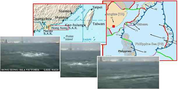
ZetaTalk Explanation 1/21/2012: What is a water fall but water seeking its level? This location, off shore from Hong
Kong, is subject to the Sunda Plate, which is just to the south, tipping down, creating a void. It is also subject to the
Philippine Plate, just to the east, tilting and folding so that excess water suddenly must find someplace to go. A
whirlpool first developed as the water coming from the east, from the Philippine Plate, was flowing east to west and
due to temperature and density differences top water dropped and thus, the tornado in the water, the whirlpool. The
whirlpool stopped as water arrived from the Sunda Plate, countering the direction of the torque. The sudden switch
to a water fall occurred as the dual rise in water from the Sunda and Philippine Plates had a dual slosh back from
both the south and east.
You received this Newsletter because you subscribed to the ZetaTalk Newsletter service. If undesired, you can quickly Unsubscribe.
|