Jakarta is Sinking
One of the 7 of 10 scenarios predicted to potentially occur before the end of 2010 was sinking of the
plate tongue holding Indonesia, at least along the southern edge holding the island of Sumatra.
ZetaTalk Explanation 4/17/2010: The Indo-Australian Plate will tip sideways so that Indonesia
can plunge under the eastern side of the plate. Islands in Indonesia will be affected by this plunge,
ultimately sinking. Do such adjustments happen all at once, or gradually? Both occur, but the
trend is unmistakable long before a major adjustment occurs.
A number of reports coming out of Jakarta indicate that Jakarta is now sinking! The areas sinking are
along canals, and in some cases on roads that have born heavy traffic for years. The land is dropping.
The first instance occurred on September 14, 2010 where a landslide 100 feet long occurred along the
East Flood Canal in South Jakarta.
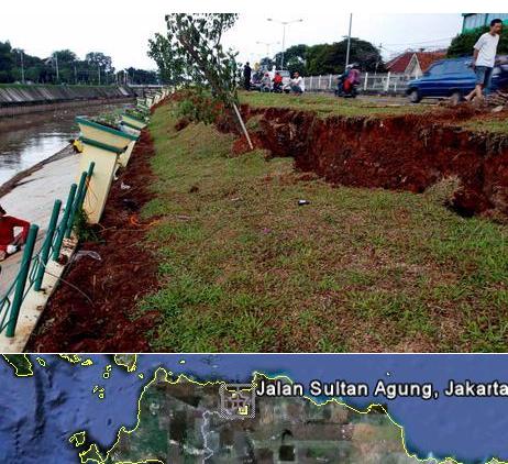
- Rain Running, Fences BKT sinkhole
September 14, 2010
http://megapolitan.kompas.com/read/2010/09/14/19515660/Hujan.Deras..Pagar.BKT.Ambles
- The rain which flushed the capital city in recent days has resulted in land on the riverside
of East Flood Canal (BKT) sinkhole and make a fence and levee BKT located on Jalan
Sultan Agung, South Jakarta, participate tilt around 45 degrees. The dike is approximately
100 feet sinkhole.
The second instance was on September 17, 2010 along the Martadinata road in North Jakarta. Official
excuses were thrown out that erosion had occurred, but the number of incidences belies this.
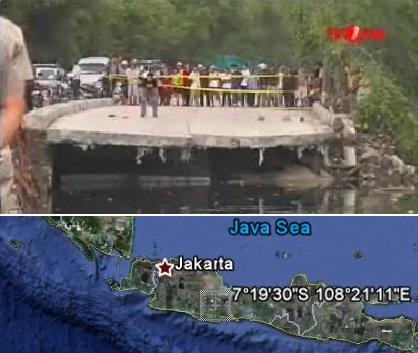
- R.E. Martadinata Road Collapsed
September 17, 2010
http://www.metrotvnews.com/itm-beta/hot-news/re-martadinata-road-collapsed
- Around 100 meters of the R.E. Martadinata road in North Jakarta yesterday collapsed
leaving a gaping hole and causing major traffic jams in the area. The road collapsed 7
meters deep at 3 AM on Thursday. The road is the main artery into Tanjung Priok port and
has disconnected traffic from Ancol to Tanjung Priok area. Early reports suspect the
damage on this newly re-constructed road was likely to be caused by a weak foundation
compounded with sea abrasion.
The third instance occurred in South Jakarta, a day later on September 18, 2010, along the Western
Canal.
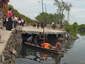
- Western Canal Levee in its Building is also Sinkhole
September 18, 2010
http://metro.vivanews.com/news/read/178166-pu-teliti-tanah-amblesnya-tanggul-kanal-barat
- After RE Martadinata Road sinkhole, now turn the retaining dikes along 115 meters of
water channels along the Western Canal, exactly Jalan Sultan Agung, Setiabudi, South
Jakarta, suffered the same fate. Levee three-meter-deep sinkhole is, not only that the
condition of concrete construction was sinking pole tilted up 45 degrees.
According to a report from someone living in Indonesia, this is unexpected and unusual!
This kind of occurrence is a new and frightening phenomenon to the Indonesians.
Some media said it was a strange phenomenon. The collapse is bound to spread to
the rest of the North Jakarta coastal areas and probably inland, according to
experts. The road sank 7 meter deep (17 Sept). Today (18 Sept), it sank 2.5 cm
more in one hour. Indonesia mainstream media reported Jakarta was sinking. (RE
Martadinata Road : 7°19'30"S 108°21'11"E)
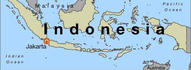
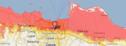
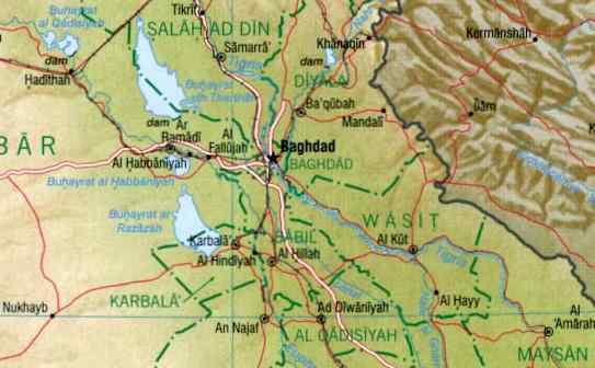
Jakarta's elevation is close to sea level. This map shows what would occur to the region with a loss of
only 50 feet in sea level elevation.
Meanwhile, Pakistan is likewise dropping, the flood waters not draining as expected. This edge of the
Indo-Australian Plate is dropping as the eastern edge curving along Sumatra tips up, thereby allowing
the plate tongue holding Indonesia to plunge. These two incidents, the lowering elevation along the Indus
River in Pakistan and the sinking in Jakarta, go hand in hand.
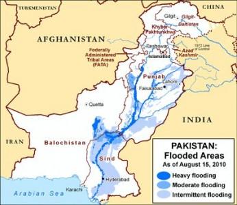
- Flooding Crisis Worsens in Pakistan
September 17, 2010
http://wsws.org/articles/2010/sep2010/paki-s17.shtml
- There are signs that Pakistan's flood crisis is worsening, with reports of new flooding in the
southern province of Sindh. The floods first struck at the end of July following heavy
monsoon rains in the northwest. The floodwaters surged down the Indus River, submerging
one-fifth of Pakistan at their peak. All over Pakistan, pools and small lakes left behind by
the floods are providing ideal breeding grounds for mosquitoes carrying the parasite that
causes malaria.
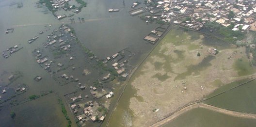
- Pakistan flooding crisis: Not over yet
September 17, 2010
http://www.cnn.com/2010/WORLD/asiapcf/09/17/photos.pakistan.flooding/index.html?iref=allsearch
- More than seven weeks after flooding first displaced millions of people in Pakistan, the
crisis is not over. Whole towns are still submerged; tent cities now dot the high ground and
line the roads that are left; and more rains have prevented some relief.
Jakarta has been sinking slowly since 2008. Per experts this is because of extraction of water from the
water table and heavy high rise buildings, but only at a rate expected to be 18 inches total by 2025. The
rate has picked up far outside of these predictions, which do not cite the correct cause. Note also that
the article states that one way to determine sinking is slowly draining flood waters, or flooding, and this
is exactly what is happening in Pakistan.
- Indonesia's thirsty capital is a sinking city
April 15, 2008
http://www.abc.net.au/news/stories/2008/04/15/2217414.htm
- By 2025, estimates from the Intergovernmental Panel on Climate Change (IPCC) show,
sea levels will have risen by only about five centimetres. But Mr Brinkman says Jakarta,
which spans a flat plain between mountains and coast, will be between 40 and 60
centimetres lower than it is now.
-
- Jakarta sinking up to 10 cm per year
April 24, 2010
http://www.thejakartapost.com/news/2010/04/24/akarta-sinking-10-cm-year.html
- Jakarta, the nation's capital and largest city, is sinking at a rate of 10 centimeters a year, a
recent study has found. The main causes for this phenomenon, which has been evidenced in
recent years by several major floods, are extensive land extraction due to groundwater
exploration and pressure from high-rise buildings, which is pushing parts of the city into
the underlying water table.
Meanwhile, per the Zetas, even those who are aware of the pending pole shift are reluctant to fully "get
it".
ZetaTalk Lament 9/18/2010: Even those who listen to our words and take them seriously are not
connecting the dots to be able to envision what these disasters will mean. All intelligent creatures
use these types of denial techniques, so we are not just criticizing mankind here. If one hears that
they can no longer use their car, because the roads will be torn up, they don't register that all
distribution of goods will be stopped or trips to the clinic for injuries will be blocked. They
imagine the car, sitting idle while the roads are repaired. It does not sink in, that the use of the
car will forever be prevented, or that the car may be flipped on its side with no means of righting
it, ever, and will rust into uselessness while the tires rot. If we say that travel restrictions will be
imposed, they imagine themselves approaching a counter and pleading their case, as is the
situation today, or bribing someone, or finding an alternate road to evade checkpoints. That the
counter will be closed, and the applicant facing a loaded rifle and told to leave, is not considered.
That bridges will be collapsed, rivers above flood tide souring the banks and washing away
boats, and side roads filled with looting thieves is not taken into consideration. When the 7 of 10
occurs, these situations, from some part of the globe, will be evident, and hopefully those who are
capable of envisioning the pending pole shift will fully "get it" at that time.
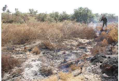
Iraq Smoldering
In the news in Iraq was a report of a panic in Najaf where the residents feared a volcano was
developing. The ground was super heated, burning a policeman's leg when he went to investigate, and
the soil so soft there it swallowed up sheep. Something was clearly amiss!
South of Baghdad 180 KM , Earth was opened up and start pump white gas. All
that happened in 2 hours, Geological say in TV news this is a new signal for
volcano activity in Iraq. We never seen something like this before. This is the link.
http://www.aawsat.com/details.asp?section=54&article=587199&issueno=11617
It is official newspaper. Also my friend call me before 10 minutes. He saw the area
this morning and he say, it is around 250 square meters area. No one can be close
to it coz of the heat temp. A police man get leg burn when he try to be close to
that area. He say that under the surface dust is an Iron fusible (AS he said). Link
in Arabic, I try to translate it to English but my computer froze.
Here are excerpts from the Google translation. Najaf is to the SSW of Iraq, and the whole region is
known to have oil though active oil wells are not present where the suspected "volcano" appeared. The
panic was quickly doused with assurances that the hot weather had merely heated the ground, which
hardly seemed the case for such an isolated spot to be so very hot. The Zetas had a different
explanation.
Panic quickly spread among the people of Najaf and its environs after hearing the
news of a volcano about to explode in a Alehiadip within the visible Najaf,
south-west of Iraq, but faded after the Dubai Department of Geological Survey,
local phenomenon natural and due to the high temperatures. frightening thing is
that a number of sheep swallowed by the earth soft and very hot, and when you
try to save the sheep have hesitated because of the severe heat of the earth.
ZetaTalk Explanation 9/25/2010: Clearly there is something hot under the ground, causing this
phenomena. This is not a volcanic zone, but this is likewise not due to general heat in the area at
a time when summer is ending. Likewise, the phenomena is localized in one spot, unlike heat
caused by weather. The plates are moving, and this includes the Arabian Plate which will turn its
pointed top to grind through Iraq, pushing central and eastern Iraq into the mountains along the
border with Iran. As it obvious from its standing as one of the major oil producing nation, a
nation with massive proven oil reserves, the rock being ground up and compressed has many oil
pockets. From one of the many reasons an underground fire can start, one of these pockets far
underground is burning, creating intense heat on the surface and melting the rock in places. For
those who ask where the oxygen can come from the sustain such a fire, we point to the many
empty oil pools which have filled with air as well a natural caverns that occur within all rock
strata.
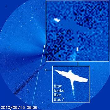
NASA's Eraser
As noted on the Pole Shift ning the many captures of Planet X or the Moon Swirls on SOHO are now
being erased, rubbed out! But a close check shows what NASA is trying to eliminate. The eraser was
evident on September 13-19, 2010 inclusive.
ZetaTalk Statement 8/20/2010: Will NASA rig every outlet by which the public can see this so it is
producing false data? They have, in any case, raised suspicions that they are up to something.
But what is certain is that the public senses they are being lied to.
You received this Newsletter because you Subscribed to the ZetaTalk Newsletter service. If undesired, you can quickly
Unsubscribe. You can always access prior Newsletters from the Archives.
|