| |
Step 1 is to research your
location in the Safe Locations information on the ZetaTalk website. In this you should examine not only
your country, your state or province, or your city but also any nearby.
Your specific town may not be covered but the whole river valley may be
predicted to flood and to flood permanently. This would be a clue that
your specific town will be likewise affected. We cannot and have
not addressed every spot on Earth, due to time and energy
constraints, as we expect you to have a brain and take this approach.
Step 2 is to research your
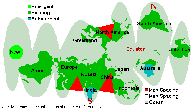
location from the standpoint of the climate that will exist after the pole
shift. This is quickly ascertained by looking at the New Geology map. This is a free map which can be cut
out and taped together and will give a general idea of the latitude to
expect. If your chosen location is where one of the new poles will be,
this is a clue that you need to rethink or plan a migration route.
Step 3 is to research your
elevation above sea level. A handy and free tool is Google
Earth which can be downloaded into a PC and will show the exact
elevation of any spot the cursor passes over. Google
Maps is a modified version that allows a color coded map based on
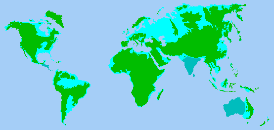
elevation. Our advice to be 100 miles from a coastline and 200 feet above
sea level to avoid the coastal tidal waves during the pole shift should be
applied. You can determine your current elevation and whether
your location will be 675 feet above sea level where the water will rise
within 2 years after the pole shift. A rough
guide in this matter is the map Nancy created. Step 4 is to
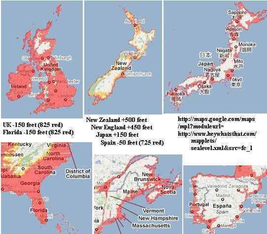
determine if you are in one of those regions which will rise or fall.
India and western Australia will be below the waves as of the time of the
pole shift, and being pushed down before the pole shift. Japan gains 150
feet, New Zealand gains 500 feet and eastern Australia benefits also,
Spain loses 50 feet, western UK loses 150 feet, New England gains 450 feet
due to the Seaway rip, Florida loses 150 feet, and Vancouver Island gains
100 feet. \
Step 4 is to determine if you are
in one of those regions which will rise or fall. India and western
Australia will be below the waves as of the time of the pole shift, and
being pushed down before the pole shift. Japan gains 150 feet, New Zealand
gains 500 feet and eastern Australia benefits also, Spain loses 50 feet,
western UK loses 150 feet, New England gains 450 feet due to the Seaway
rip, Florida loses 150 feet, and Vancouver Island gains 100 feet.
Step 5 is to research the effect
of swollen rivers which will likely be in a backwash during the pole
shift. We have stated that all rivers will be over their banks,
so the worst possible scenario should be assumed. What will happen if the
river cannot drain? Despite having a good sea level elevation, any land
that does not have an advantage of being at least 200 feet in elevation
over a major river bottom in the vicinity is likely to be flooded. A
backwash from the main river in your vicinity should be assumed, so that
creeks will not drain, for instance. Water on
the move tears and bites and scours, and will undercut the soil
under buildings so they will tilt and tumble. Being on solid rock that
will not melt in this scenario is advised. Tidal bore along cliffs facing
the ocean can likewise have water climbing up, or funneled up by ravines
which will direct water all the way to Guadalajara from the Pacific, for
example. Think this through, for your location, and be on the safe side.
Step 6 is to examine your volcanic
or geographic risk due to mountain building. We have advised a 100 mile
radius from all volcanoes that have been active within the last 10,000
years, and that Yellowstone will not become a super volcano. You
can determine if the new westerly winds will blow volcanic ash in your
direction. Consider that what was formerly north will
now be west or east. Fire storms, though extremely rare, almost
always occur near erupting volcanoes during the hour of the pole shift. We
have advised that if in areas subject to mountain building that old rock
not shattered is a good guide to what will survive, and newly fractured
rock is a clue that more of the same might be expected. Older mountains as
the Alps and Appalachians are considered safe, where the Sierras and Andes
are building.

Step 7 is to ascertain if you need
a migration route. It is possible to survive the pole shift by avoiding
tidal waves and staying outside of structures that will crush you, but to
be in a position to be flooded within 2 years after the pole shift.
Siberia is a case in point. Here the land is so low in elevation that vast
swaths of land will be flooded, and survivors must plan to migrate on foot
or via boat. Survivors near the new N Pole off the Bulge of Brazil might
consider migrating toward the Andes and their familiar tropical warmth.
Such migration, and your target location, can be plotted. Migration routes
can be expected to be crowded, so should be avoided as a location for
survival camps in general.