| |
Written October 16, 2010
For the past few months I've just been reading this site but now I registered so I can ask a question. Regarding the Indo-Australian plate tipping, I guess no one has asked this question yet: How much elevation will the areas affected by this plate tipping such as India, Bangladesh, Indonesia, Malaysia and Philippines lose? I think this information is important so we can know which higher areas people can go to when the process starts. [and from another] I would like to ask how much of the Philippines, particularly Manila will be affected when 7 of 10 happens? Will there be lots of lives lost? Can you provide more details regarding this?
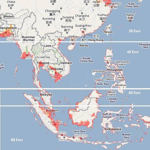
We have spoken previously of the areas to be affected by the bending of the tongue holding Indonesia, but can now give more specifics. Draw a line from the city
of Hangzhou directly east, and consider this horizontal line the point of bend. This does not mean that points north can rest easy, as when the tongue bends down
water from various sides will rush in to fill the void, and these waters will have a rebound in the form of tsunami which can race northward at a height of 20-30 feet.
The southern coast of China was likewise warned that they could experience loss of elevation. How much will their coastline drop, that they needed this warning
from the Hangzhou UFO? This coastline, in general, can anticipate losing 20 feet in elevation, which will likewise afflict Taiwan though Taiwan is high land and will
not be as devastated.
Though the tipping of the Philippine Plate at first gives the islands of the Philippines some relief, as the subduction of the plate is pushing under them, as the bending
of the tongue holding Indonesia progresses, they too find an astonishing loss of sea level. However, other than some small islands and the direct coastline, little of
the Philippines will be affected by this rise in sea level, and safety can be gained if the coastal residents head for the hills at the first sign of sinking. Tsunami will
affect the Philippines, to a potential height of 40 feet, so a prompt evacuation to be at least 20 miles inland is necessary. If the coast of southern China will lose 20
feet in elevation, the Philippines will ultimately lose twice that much, to a total loss of 40 feet in elevation. Due to the tilting of the Indo-Australia Plate, Bangladesh
gains temporary relief from the steady sinking it has experienced the past few years. And the tsunami likely to race northward will not come their way because the
waters from the Bay of Bengal will be rushing into the South China Sea, and there clashing to push north. If the loss of 40 feet in elevation is not devastating to the
Philippines, it is to the coastline of southern Burma, Tailand, and Cambodia, which have vast areas that will suddenly and permanently be flooded.
It is the southern tip of the tongue which is utterly devastated. Draw a line just north of the Malaysia border and over the top of Borneo. The land on the tongue
from this point south will double its elevation loss, so that Java and the islands bordering the Banda Sea will find they have lost a full 80 feet in elevation, sinking
many coastal cities and small islands out of sight. Singapore will be awash, its streets hopelessly inundated. Vast areas of the northern coastline of Sumatra and the
southern coastline of Borneo will likewise be inundated. And if having the sea rush in were not horrific enough, the sudden drop in elevation will bring with it water
from the Indian Ocean and the Philippine Sea which will create turmoil, unpredictable waves that clash and boil. There is no predictor indicating that the bend and
drop are about to happen that we could point to. There are, as we mentioned there would be, indicators of the direction that the plates are being pushed, as Jakarta
has been sinking, Pakistan sinking, and the Coral Sea floor rising. We are telling you your coastlines are not safe, and the rest is up to you!
Written October 23, 2010
Would the Zeta elaborate a bit how the sea water coming from the Indian Ocean and the Philippine Sea during 7 of 10 will boil? When you say: "And if having the sea rush in were not horrific enough, the sudden drop in elevation will bring with it water from the Indian Ocean and the Philippine Sea which will create turmoil, unpredictable waves that clash and boil. http://zetatalk3.com/info/tinfx341.htm 7 of 10 Elevation.
Boiling water, as seen in a pot, has water splashing about on the surface, bubbles rising up from the bottom of the pan where steam is being formed. This is water
with tides moving in multiple directions, in the pot. Super heated water is rising from the center, filled with bubbles that burst on the surface, while cooler water
cycles back along the sides of the pot. The concept of the seas boiling is such that water of uneven presure is clashing, such that water from one source forges
through the waters coming from another direction. Such a clash can create water going into a circular direction, seeking to release its pressure, and such circular
motion can create huge whirlpools. These are of legend during pole shift times. If the water under pressure is also cold, it tends to create an undertow, creating
strange movement on the surface where the surface water seems to be rippling in this or that direction for no reason. Such undertows can be very dangerous. If
something on the surface gets caught in the tow, it will not surface for a long time, potentially drowning those in boats or floating on flotsam. Warm water tends to
rise to the surface, and if breaking through colder water on the surface, will likely explode there, giving the impression that the seas are boiling.
All rights reserved: ZetaTalk@ZetaTalk.com